CRITICAL 2024/2025 CLOSURES
PÖLLAT GORGE: CLOSED INDEFINITELY due to rockfall risk. The scenic route under Marienbrücke is inaccessible. Use the paved road or shuttle bus.
ALPENROSENWEG: Closed due to severe storm damage on Füssen side. Route via Fürstenstraße or lower road required.
WARNING: Ignoring these closures is dangerous—the geological instability is real.
The Operational Reality: A Study in Contrasts
The Dreischlössertour exists at the intersection of high-alpine splendor and industrial-scale tourism. For the uninitiated, it's marketed as a gentle promenade connecting fairy-tale structures. The reality is far more complex, requiring nuanced understanding of topography, crowd dynamics, and logistical timing to navigate successfully. The route connects the medieval Hohes Schloss in Füssen, the neo-Gothic Schloss Hohenschwangau, and the world-famous Schloss Neuschwanstein. While the view payoff is undeniably world-class—offering perspectives that 90% of bus-tour visitors never witness—the trail demands respect for the strategic planning required, not technical difficulty. This is NOT an "easy walk" despite what generic apps claim.
The Only Terrestrial Location
The Kalvarienberg Summit is the ONLY spot where all three castles align in a single field of view. The castles appear as miniatures against a massive alpine backdrop. Telephoto lens (70-200mm) essential—smartphones render castles as distant dots.
The Crowd Paradox
The trail offers moments of sublime alpine silence AND intervals of urban congestion. The 500m section near the ticket center can take 20 minutes to traverse during peak hours. The Kalvarienberg ridge? A sanctuary of quiet.
Real Time Investment
Digital tools estimate 2h44m—operationally useless. Realistic: 3.5 hours hiking. Photographer/Sightseer pace: 5-6 hours. Allocate a full half-day (08:00-14:00).
Start Strategy: Füssen "Smart" Start
Parkplatz Morisse (Kemptener Str.) is cheaper than castle lots. Tackle Kalvarienberg ascent while fresh. End in Füssen near authentic dining, not tourist traps.
Marienbrücke Reality
The classic postcard side-profile view. The catch: 20-45 minute queue just to step onto the structure during peak season. Industrial, loud, cramped. A "check-the-box" moment.
Footwear Critical
Athletic sneakers "doable" in dry weather but suboptimal. The Kalvarienberg limestone steps become slick when wet—akin to soapy tile. Light hiking boots or aggressive trail runners required.
Free Bus Loophole
Füssen Card or KönigsCard = FREE BUS RIDES (lines 73, 78) connecting Füssen to castles. Enables linear hike without backtracking to car.
Trail Profile: A Forensic Breakdown
Route Geometry
- Total Distance: 10.3 - 12.5 km (variance depends on micro-detours and closure routing)
- Elevation: +/- 310-450m (NOT gradual—concentrated in two sectors)
- Format: Loop system (point-to-point psychological experience, scenery constantly evolves)
Time Investment Reality
| Pace Type | Duration | Description |
|---|---|---|
| Athlete's Pace | 2h 15m | Fit hiker, no stops except hydration, bypassing viewing platforms |
| Realistic Hiker | 3h 30m | Standard enthusiast stopping to appreciate topography and navigate signage |
| Photographer/Sightseer | 5-6 hours | High-quality images, waiting for cloud clearance, navigating Marienbrücke crowds |

Terrain Composition: A Triptych of Surfaces
Phase 1: Kalvarienberg Ridge (Füssen Side)
The "true hiking" portion. Rocky, root-laced forest path interspersed with Stations of the Cross— religious shrines connected by stone steps.
- Technicality: Moderate. Steep gradient, active quadriceps engagement, deliberate foot placement required.
- Surface Hazard: In wet conditions, limestone bedrock and polished stone steps become exceptionally slick. Creates a "filter" discouraging casual tourists in street shoes.
- Atmosphere: Quiet, alpine foothills, contemplative.
Phase 2: The Lakes (Schwansee & Alpsee)
Terrain flattens into wide, manicured forest roads (Forststraßen) and compacted gravel paths.
- Technicality: Easy. Essentially a park walk. Portions around Schwansee accessible to sturdy strollers.
- Surface: Well-drained gravel.
- Atmosphere: Serene, park-like, expansive views.
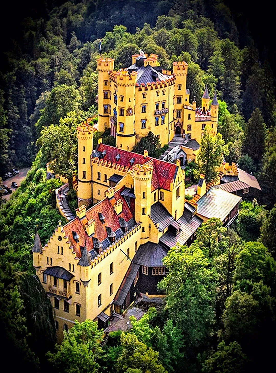
Phase 3: The Castle Zone (Hohenschwangau)
Shifts to paved asphalt roads and wide, heavily trafficked gravel tracks designed for mass tourism and service vehicles.
- Technicality: Easy footing but physically draining—relentless steep incline on hard pavement.
- Surface: Asphalt and compacted grit.
- Atmosphere: High-density urban tourism, noise pollution, shuttle buses and horse carriages.
The View Payoff: Visual ROI Analysis
The Kalvarienberg Summit: "God's Eye" View
The undisputed highlight. From the viewing platform near the summit chapel, look down upon a grand amphitheater: Hohes Schloss to the left, Hohenschwangau (yellow) and Neuschwanstein (white) straight ahead, framed by Säuling mountain and Tannheim peaks.
EQUIPMENT NOTE: Distances are significant. To compress the perspective and make castles appear large against mountains, a telephoto lens (70-200mm equivalent) is essential. Smartphone cameras will capture the "scene" but render castles as distant dots.
The Schwansee Reflection: "The Mirror"
On a calm morning, the dark, nutrient-rich waters act as a perfect mirror. Hohenschwangau reflects clearly with Neuschwanstein looming above. Unlike chaotic Alpsee, Schwansee is often deserted—clean compositions without tourists in frame.
Light Dynamics
- Sunrise (SUPERIOR): Light hits front/side facades of castles directly. Lakes shrouded in morning mist. High-contrast scenario favored by photographers.
- Sunset (INFERIOR for castles): Mountains behind castles cast shadows, plunging Neuschwanstein into shade hours before actual sunset. However, view toward Füssen is spectacular.
When To Go: Strategic Temporal Planning
Seasonal Analysis
| Window | Months | Assessment |
|---|---|---|
| The "Epic" Window | Late May, June, Sept, Oct | Optimal balance. Snow melted, crisp air, clarity for distant peaks. October "Golden Autumn" = vibrant forest colors against blue lakes. |
| The "Sweat" Window | July, August | Cauldron-like valley traps heat. South-facing Kalvarienberg ascent feels 5-10°C hotter. Marienbrücke = mosh pit of selfie sticks. AVOID unless necessary. |
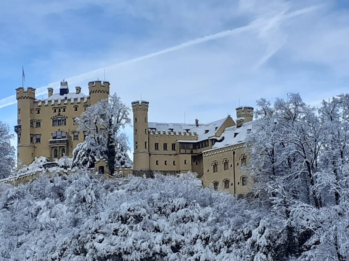
| The "Moody" Window | Nov - March | Snow common. Kalvarienberg steps become ice luge. Traction cleats (Grödel) MANDATORY. Lower Schwansee loops typically cleared—safer winter alternative. |
Daily Rhythm
- 07:00-09:00 (Golden Hours): Locals and informed hikers only. ONLY window to walk Marienbrücke without physical contact with strangers.
- 10:00-15:00 (Tourist Crush): Munich tour buses arrive in waves. Village functions like crowded theme park. Constantly stepping aside for groups.
- 16:00-19:00 (Cool Down): Crowds thin rapidly as buses depart. Excellent for loop if castle interiors (close ~18:00) not a priority.
Crowd Survival Strategies
The "Zonal" Crowd Map
| Zone | Density | Character |
|---|---|---|
| Zone 1: Kalvarienberg | LOW | Only dedicated hikers venture here. A sanctuary of quiet. |
| Zone 2: Schwansee | MEDIUM | Families and locals walking dogs. Standard public park feel. |
| Zone 3: Hohenschwangau Village | EXTREME | Wall of humanity. Patience and defensive walking required. |
| Zone 4: Neuschwanstein Ascent | HIGH | Paved road with walkers, strollers, horse carriages. |
| Zone 5: Alpsee Circular | MEDIUM | Thins exponentially with distance from boat rental. |
The Reverse Loop Strategy
Most visitors instinctively hike Castle → Alpsee. Consider hiking clockwise (Füssen → Kalvarienberg → Schwansee → Castles). This tackles physical exertion in the quiet morning and hits busy areas later when mentally prepared for the contrast.
Access Logistics
Trailhead Strategy
| Option | Location | Cost / Notes |
|---|---|---|
| Option A: "Castle" Start | Lots P1-P4, Hohenschwangau | ~€10-12/day. Fills by 09:30 on weekends. Afternoon exit = 30-min traffic jam. |
| Option B: "Smart" Start | Parkplatz Morisse, Füssen | Cheaper/sometimes free. Tackle Kalvarienberg while fresh. End near authentic dining. |
The Füssen Card Loophole
For overnight guests: Füssen Card or KönigsCard grants FREE BUS RIDES (lines 73, 78). Park at hotel, bus to castles, hike back to Füssen—linear hike, no backtracking.
On-Trail Water
NO natural springs, fountains, or potable water on Kalvarienberg ridge or Schwansee loop. Carry at least 1.5L per person. Only refill options: crowded castle restrooms or expensive kiosk beverages. The south-facing Kalvarienberg ascent is dry and hot—dehydration common for unprepared tourists.
Mountain Huts and Gastronomy
| Option | Location | Character |
|---|---|---|
| Rohrkopfhütte | Above castles (45-60 min steep hike detour) | Authentic rustic Bavarian hut. Kaiserschmarrn, Kässpätzle. CASH ONLY. Worth the extra effort to escape "sneaker tourists." |
| Schwansee Kiosk | North shore Schwansee | Hidden gem. Relaxed, local, unpretentious. Coffee, homemade cakes, Currywurst. Bus tourists never venture here. Clean toilets. May-Oct, 10:00-18:00. |
| Schlossbrauhaus Schwangau | Near ticket center | Large-scale tourist beer hall. Solid local beer, generous portions. Reliable if starving. |
| Alpenrose am See | Alpsee shore | Upscale hotel terrace. Premium pricing pays for 10/10 water view. Celebratory end-of-loop drink. |
Post-Hike Füssen Dining
Avoid eating in castle village—overpriced and mediocre. Proceed to Füssen Old Town. Recommendations: Il Pescatore (high-quality Italian/Seafood) or Gasthof Krone (medieval atmosphere, reliable Bavarian staples).
The Brutally Honest Step-by-Step
Phase 1: The Ascent (Füssen to Kalvarienberg)
- Park at Morisse in Füssen. Walk south toward Lech River, cross Lechbridge.
- On far side, locate sign for "Kalvarienberg."
- The Grind: Path transforms into Stations of the Cross chapels. Steep, uneven stairs. Expect to sweat significantly.
- The Reward: Upon reaching "Hirschwiese" (Deer Meadow) and summit chapel, DO NOT bypass the viewing platform. This is THE photo spot.
Phase 2: Descent to Schwansee
- Follow signs descending toward Schwansee through dense forest (can be muddy).
- Emerge at "Schwanseepark"—flat, grassy royal English landscape garden.
- Walk shoreline for superior views or center path for speed.
- Pit Stop: Schwansee Kiosk located here. Use facilities.
Phase 3: The Castle Gauntlet
- Hike UP to Hohenschwangau village.
- The Shock: Emerging from quiet forest into parking lot of tour buses is jarring.
- Proceed past Ticket Center, follow signs to Neuschwanstein.
- Shuttle Bus: €3.00 uphill. Long lines. Generally NOT worth it for fit hikers.
- Marienbrücke: Visit if compelled, but anticipate the wait.
Phase 4: The Return (Alpsee & Detour)
- Descend from castle to Alpsee. Walk north shore.
- CRUCIAL: Alpenrosenweg is likely CLOSED. Scenic cliffside path to Lechfall inaccessible.
- Workaround: Route via Fürstenstraße or lower road back toward Schwansee/Füssen.
Final Tactical Advice
- Start at 08:00 AM from Füssen to beat the bus waves.
- Wear real hiking shoes. The Kalvarienberg is not terrain for flip-flops.
- Bring cash for the huts.
- Respect "Closed" signs. The rockfall danger in Pöllat Gorge is real.
- Carry 1.5L water minimum. No refill options on the ridge.
Practical Information
Comparative Trail Analysis
| Feature | Dreischlösserweg | Tegelberg Summit | Alpsee Loop |
|---|---|---|---|
| Character | Hybrid: Ridge + Cultural | Pure Alpine Ascent | Lakeside Promenade |
| Exertion | 5/10 | 8/10 (900m+ gain) | 2/10 |
| Crowds | Variable (quiet ridge / packed castles) | Medium | Medium-High |
| View Payoff | UNIQUE: Only 3-castle view | Panoramic Alps | Castle reflections |
| Duration | 3.5-5 hours | 5-7 hours | 1.5-2 hours |
| Best For | "Complete Experience" | "Sporty" hiker | Families / Relaxed |