The Paradox of Hohenschwangau: Extracting Value from Chaos
The Alpsee Loop represents one of the most singular paradoxes in the German Alps. Geographically, it is a pristine alpine basin—a relic of the last ice age holding water of such clarity that it mirrors the sky with near-perfect fidelity. King Ludwig II himself considered it his favorite lake. Strategically, however, it sits at the epicenter of the most intense mass-tourism zone in Central Europe. For the discerning hiker, this creates a complex tactical environment. The objective: extract the immense visual value while neutralizing the friction from 1.5 million annual visitors.
The Counter-Clockwise Strategy
Hike CCW to clear the crowded promenade first, then enjoy the quiet south shore while viewing the castles head-on during the return leg. This is the optimal directional choice.
The Filter Effect
Crowd density drops from 100% on the promenade to 20% on the south shore the moment asphalt ends and roots begin. The terrain filters out fashion sneakers and sandals.
The South Shore "Windows"
Elevated 40-50m above water, tree-framed openings offer the best Neuschwanstein views—looking across at the castle, not up. Telephoto lens territory (70-200mm).
THE "STROLLER TRAP" WARNING
The path starts deceptively wide and smooth, acting as a funnel that traps unprepared visitors on the far side of the lake. The south shore is heavily interlaced with root systems and polished limestone rocks—impossible for strollers. Unless prepared to CARRY your stroller for 1-2 km, the full loop is not an option for wheeled transport.
P4 Is The Only Logical Choice
Parking P4 (Alpsee Parkplatz) is directly at the lake. €12 for 6 hours + €1/hr after. Fills by 09:30 in peak season. If full, P1-3 mean 15-min uphill walk through crowds.
Alpseebad Closure Alert
The Alpseebad is scheduled for complete closure for renovation in 2025/2026. Verify kiosk status locally—if closed, there is NO food on the trail loop.
80% Shaded = Hot Day Option
The trail winds through mature forest. Excellent for 30°C+ days when the exposed castle roads are baking. Natural air conditioning (but still pack SPF for clearings).
Golden Windows
Pre-09:00 AM: Local's Hour. P4 empty, water still, loop in solitude.
Post-16:00: Day-trippers retreat. Best light, relaxed vibe.
Trail Profile: The Hard Data
| Metric | Value | Operational Reality |
|---|---|---|
| Loop Type | Circular | Counter-clockwise is superior—clears crowds first, castles head-on on return |
| Distance | 5.2-5.5 km | Guidebooks cite 3.5-4km (lakeshore only). From P4, realistic is 5.5km. |
| Elevation | ~70-120m total | Deceptive—not single ascent but undulations. Trail climbs ~50m above lake. |
| Highest Point | 872m | Schwarzenberg slopes and Pindarplatz viewpoint |
| Hiking Time | 1.5-2.0 hours | Pure moving time. With photos/breaks/navigation, budget 2.5 hours. |
| Technical Rating | T1 / T2 | North shore T1 (sneakers OK). South shore T2 (roots, rocks, sure-footedness). |
Surface Analysis by Sector
Sector 1: The Promenade (North Shore)
From the Museum to the Alpseebad (~1.5 km). Asphalt and compacted gravel. Wide enough for two strollers to pass abreast. Wheelchair accessible with assistance. Highest foot traffic—tour groups, families, killing time before castle slots.
Sector 2: The Transition (West End)
Past the Alpseebad, asphalt ends. Narrower dirt path with uneven surfaces, small stones, and mud patches after rainfall. Jogger strollers with pneumatic tires can manage with effort; city prams begin to struggle.
Sector 3: The Hiker's Path (South Shore)
The definitive "stroller trap." Single track in places, heavily interlaced with mature root systems. Smooth polished limestone rocks become slick when wet or leaf-covered. Short steep pitches, narrow wooden footbridges, and stairs require lifting a stroller entirely. For hikers: the most rewarding section—tactile terrain engagement, significantly reduced noise.
Signature Viewpoints
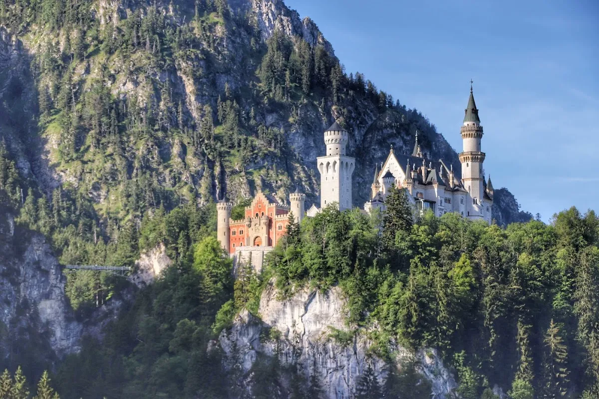
1. Pindarplatz (North Shore Outcrop)
~500m west of Museum of the Bavarian Kings. Rocky spur jutting into the lake.
- The View: Aligns perfectly with Hohenschwangau Castle—appears to float above treeline, framed by Säuling slopes. Neuschwanstein visible higher and left.
- Strategic Value: Easily accessible (Sector 1), doesn't require full loop. Primary "trophy shot" location if time is limited.
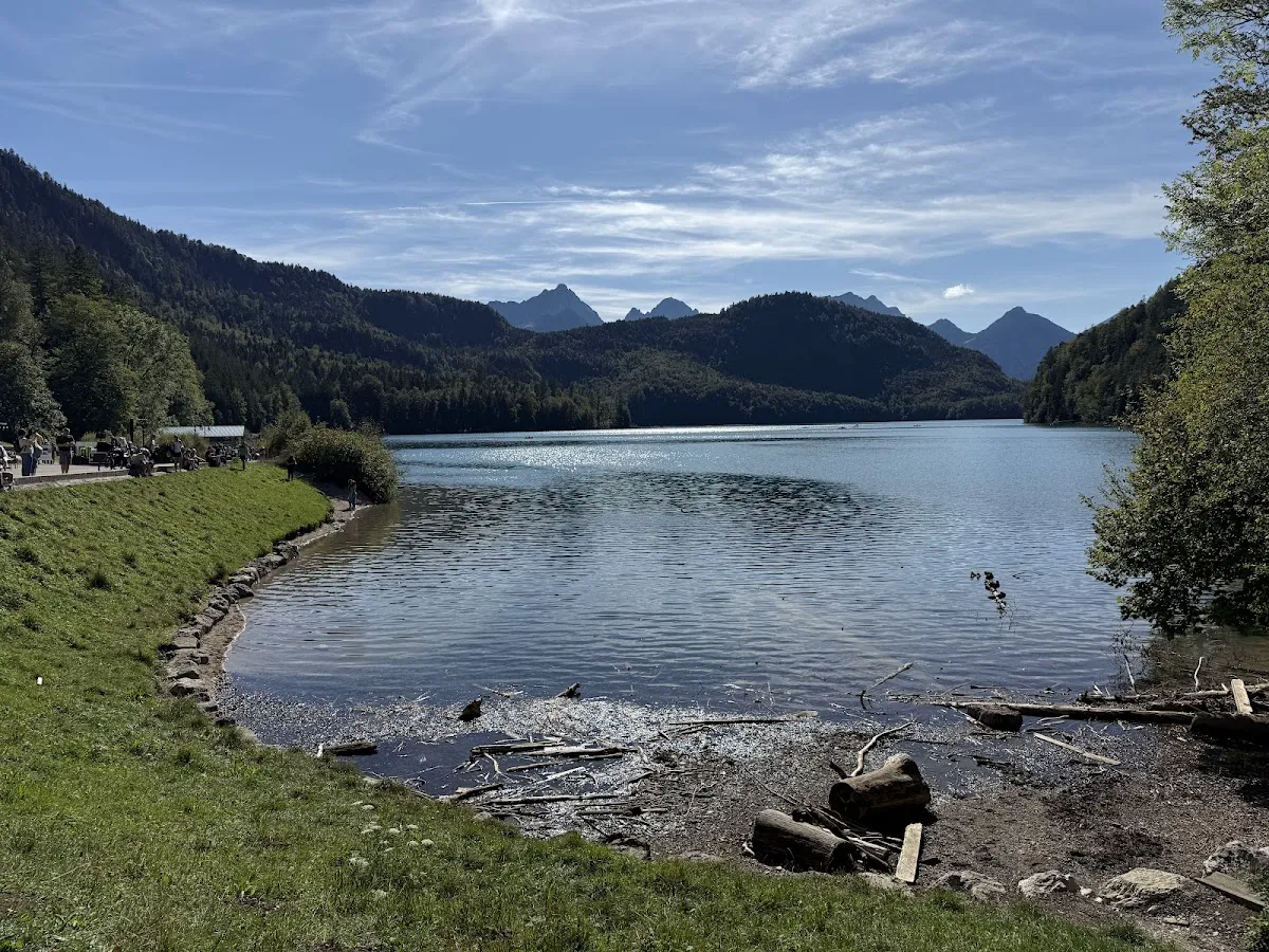
2. The Marienmonument (Western Terminus)
Far western tip of lake, dedicated to Queen Marie of Prussia.
- The View: Longitudinal perspective across entire lake length. Castles appear as small jewel-like structures in vast mountain amphitheater. Scale over architecture.
- Atmosphere: Furthest from parking = often the quietest. Prime contemplative break spot.
3. The South Shore "Windows"
Trail climbs 40-50m above water through dense forest.
- The View: Tree-framed openings offer BEST Neuschwanstein views. Elevated angle lets you look across at the castle, appreciating its verticality against Forggensee backdrop.
- Photography Tip: Telephoto lens (70-200mm) highly effective to compress distance between foreground trees and castle turrets.
Lighting Strategy: The Photographer's Clock
| Time | Conditions | Best For |
|---|---|---|
| Sunrise (Blue Hour) | Lake in shadow until mid-morning. Water glass-still before thermal winds (10 AM). | Reflections. Castles silhouetted or softly lit by ambient skylight. |
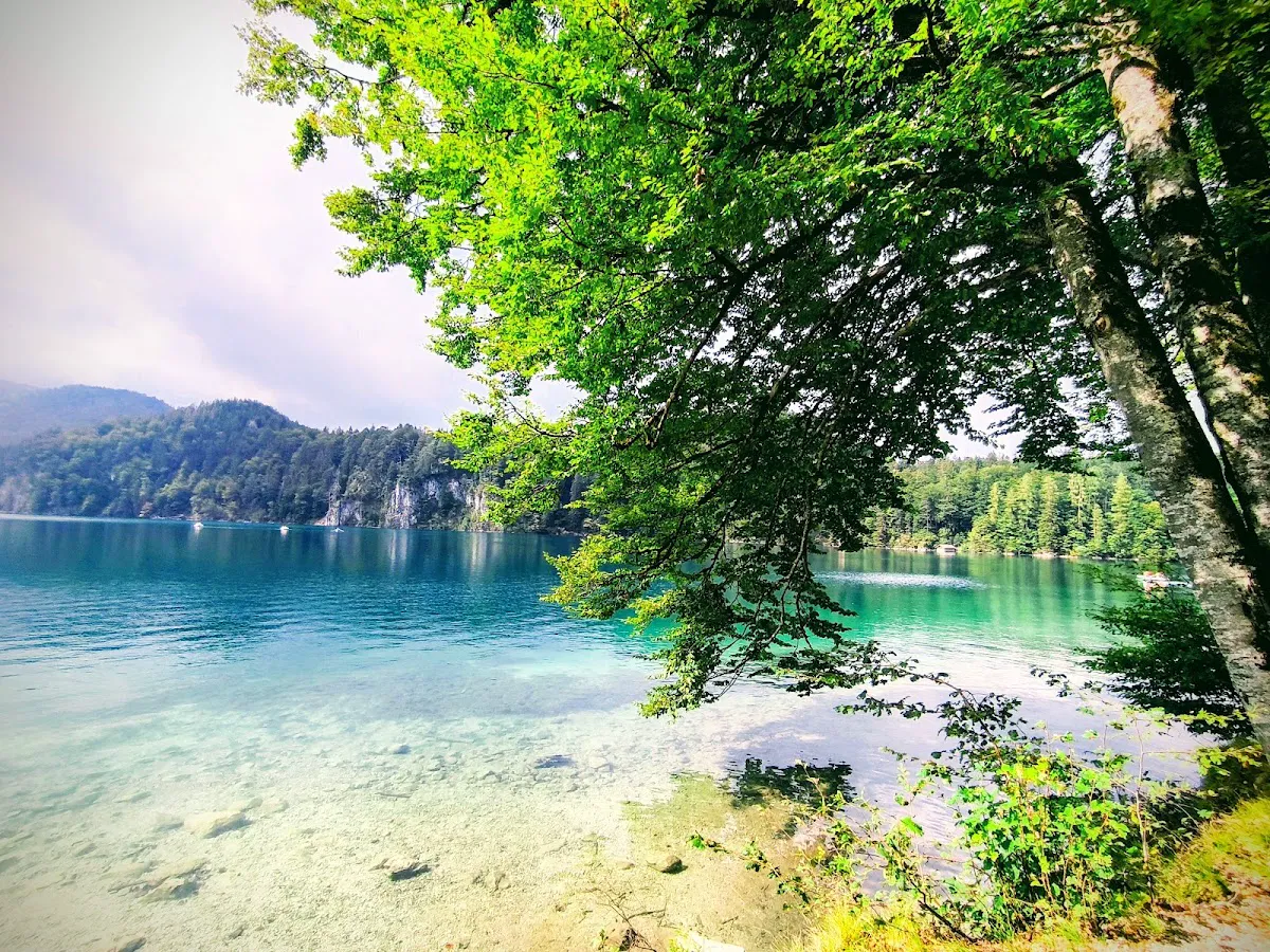
| Midday (11-14:00) | Harsh, overhead. Water turns brilliant turquoise. | Wide shots of water color. Unflattering shadows on castle façades. |
| Golden Hour (Late Afternoon) | Prime window. Sun on western/southern castle faces. | Hohenschwangau glows ochre. Neuschwanstein turns warm ivory. THE classic shot from north shore. |
The Parking Game
Access strictly controlled. No free street parking. Unauthorized vehicles quickly ticketed or towed.
| Lot | Cost (2025/26) | Notes |
|---|---|---|
| P4 (Alpsee Parkplatz) | €12 for 6 hrs, +€1/hr after | Only logical choice for hikers. Under 3 min to trailhead. Fills by 09:30 peak season. |
| P1, P2, P3 | ~€12 | Contingency if P4 full. At village entrance = 10-15 min uphill walk through crowds to lake. |
Payment Reality: Machines accept cash and cards, but card reader reliability is intermittent. Carry €15-20 in coins/small bills as tactical reserve.
Public Transit Strategy
- Train: Füssen (regular from Munich/Augsburg)
- Bus: RVO Bus 73 or 78 from Füssen Bahnhof
- Stop: "Hohenschwangau Neuschwanstein Castles" → walk past Ticket Center, downhill to Museum
- Cost Analysis: ~€5/person round trip. Solo hiker = economically superior to €12 parking. Group of 3+ = car wins.
- RISK: Last bus often 18:00-19:00. Missing it = €15-20 taxi. Check schedule daily.
On-Trail Reality
Water & Hydration
The Alpsee is exceptionally clean but NOT potable without filtration (agricultural runoff, waterfowl). No fountains on the loop. Carry 1.0-1.5L per person for summer hikes—forest humidity is high.
Cell Signal
Strong (4G/5G) on north shore and near village. Southwest corner is a dead zone (shadow of Austrian border mountains). Download offline maps before leaving P4.
Dogs
Trail is dog-friendly and popular with owners. Leashes strongly recommended due to narrow south shore paths and likelihood of encountering other dogs/swans. Dogs strictly forbidden in Alpseebad fenced area.
Bikes
Not explicitly banned but heavily discouraged. South shore root network is miserable for gravel bikes, dangerous for casual cyclists. Serious MTBers bypass for Jägerhütte trails.
Seasonal Conditions
| Season | Conditions | Crowd Factor | Notes |
|---|---|---|---|
| Summer (Jun-Aug) | Lush green, turquoise water, hot/humid | EXTREME | Hike before 09:00 or after 17:00. Midday = swimming, not hiking. |
| Autumn (Sep-Oct) | PEAK VISUALS. Golden leaves + blue water. | High | Early mornings for mist and atmospheric shots. |
| Winter (Nov-Mar) | Snow-covered, potential frozen lake | Low | Microspikes mandatory. South shore is icy slide. Silence is profound. |
| Spring (Apr-May) | Snowmelt, muddy, high water | Moderate | Good visibility through leafless trees. |
Winter Realities
Serious undertaking. Village roads salted, but south shore often left semi-wild. Frozen hiker-packed snow becomes undulating ice sheet. Without traction devices, rooty sections are hazardous.
Lake Ice Warning: In sub-zero periods, Alpsee freezes (locals skate/curl). However, warm underwater springs create thin spots. NEVER venture onto ice unless officially cleared and marked by authorities.
Swimming: Regulations vs. Reality
Official Status
Entire shoreline is Landscape Protection Area (Landschaftsschutzgebiet). To protect reed belts (breeding grounds for grebes/coots), entering water from reeds is strictly prohibited.
The Alpseebad
Sanctioned solution with pier, raft, changing cabins, toilets. Only place where swimming is officially "encouraged." 2025/2026 CLOSURE for renovations—verify status locally.
Wild Swimming Reality
Occurs at specific gravel clearings along north shore and near Pindarplatz. Generally tolerated if discreet, no vegetation trampling, no heavy sunscreens, no noise. Technically a violation. With Alpseebad closure, expect stricter enforcement or more "Forbidden" signage.
Combo Strategies: Justify the €12 Parking
The loop is a 2-hour activity. Pair with other objectives to maximize value.
1. The Schwansee Extension (The Quiet Sister)
From P4, connector trail through forest to Schwansee. Smaller, shallower, lacks castle crowds. Stunning view UP to castles from valley floor. Follow signs for "Fischersteig"—adds ~1.5 hours, flat and peaceful. Perfect antidote if Alpsee feels too busy.
2. Museum of the Bavarian Kings
Located exactly at the trailhead. Provides intellectual context—learn about the Wittelsbach dynasty. Modern, air-conditioned (great for hot days), rarely crowded. Café Alpenrose am See accessible without museum ticket.
3. Hohenschwangau Castle Courtyard
While Neuschwanstein requires tickets and long ascent, Hohenschwangau courtyard/gardens often accessible with less friction. 15-20 min steep walk from P4. Elevated view looking DOWN on Alpsee reveals full color gradient from turquoise shallows to deep indigo center.
The Picnic Strategy
Given high costs and potential closures, the most tactical approach is self-supported picnic. The benches at the Marienmonument offer a dining view that no restaurant in the village can match. Purchase supplies at REWE/Lidl/V-Markt in Füssen before driving up.
Safety & Emergency
- Emergency: 112 (EU)
- Local Response: Bergwacht Füssen (Mountain Rescue)
- Reality Check: Rescue teams often overwhelmed dealing with castle incidents (dehydration/exhaustion on steep paved roads). Response times to south shore may be delayed.
- Self-Rescue: If you twist ankle on south shore, fastest extraction is often by boat (if rental/water rescue active). Otherwise, stretcher carry-out.
- Navigation: If disoriented or caught in darkness, stick to shoreline. Do NOT shortcut vertically up Schwarzenberg slope—terrain becomes cliffy and unstable.
The Final Verdict
The Alpsee Loop is a high-value objective that justifies the logistical friction of its location. By treating it as a tactical operation—arriving early, parking strategically, equipping for technical terrain—the hiker can pierce the veil of mass tourism and connect with the landscape that captivated a king.
The path you walk today is largely the same path trodden by Ludwig II as he contemplated building Neuschwanstein on the ridge above. That historical thread elevates a simple lake loop into something extraordinary.