The "Open Source" Alternative
While the Highline179 charges admission and spans a highway, the Holzgau Suspension Bridge spans a wild alpine gorge and charges nothing. Located on the famous "Lechweg" long-distance trail, this 200.5-meter oscillating steel structure hovers 110 meters above the roaring Höhenbach stream. The "free" label is accurate regarding the toll—but you pay with effort. The mandatory approach hike acts as a natural filter, reducing crowd density compared to roadside attractions.
The Sound of Silence
Unlike the Highline179 over the B179 highway, Holzgau spans a natural gorge. The soundscape is rushing water and wind, not trucks. This creates a more primal, "wilderness" fear that purists prefer.
The Adventure Triangle
Holzgau is the linchpin of a sophisticated ecosystem: the bridge, the Simmswasserfall Via Ferrata, and the Lechweg long-distance trail. This interconnectedness creates compound value exceeding the sum of its parts.
The "Sway" Factor
The bridge is lighter than Highline179 and designed to move. In gusts over 20 km/h, expect persistent side-to-side sway. Groups walking in sync can excite the natural frequency, causing a vertical "bounce" effect.
No Crowds (Relatively)
The 30-45 minute uphill approach hike serves as a "filter." Unlike drive-up attractions, you must earn this crossing. Peak weekends can still see 50+ people on the bridge simultaneously.
Night Operations
The bridge is LED-lit along the handrails. Night crossing is permitted and surreal—the village lights twinkle below, and the gorge becomes a black void. A unique post-dinner activity.
Dogs Allowed, But...
The steel grating is extremely uncomfortable for paws. Small dogs are often carried. Large dogs frequently freeze in terror when they see the void through the floor. Consider leaving pets in the village.
Width Warning
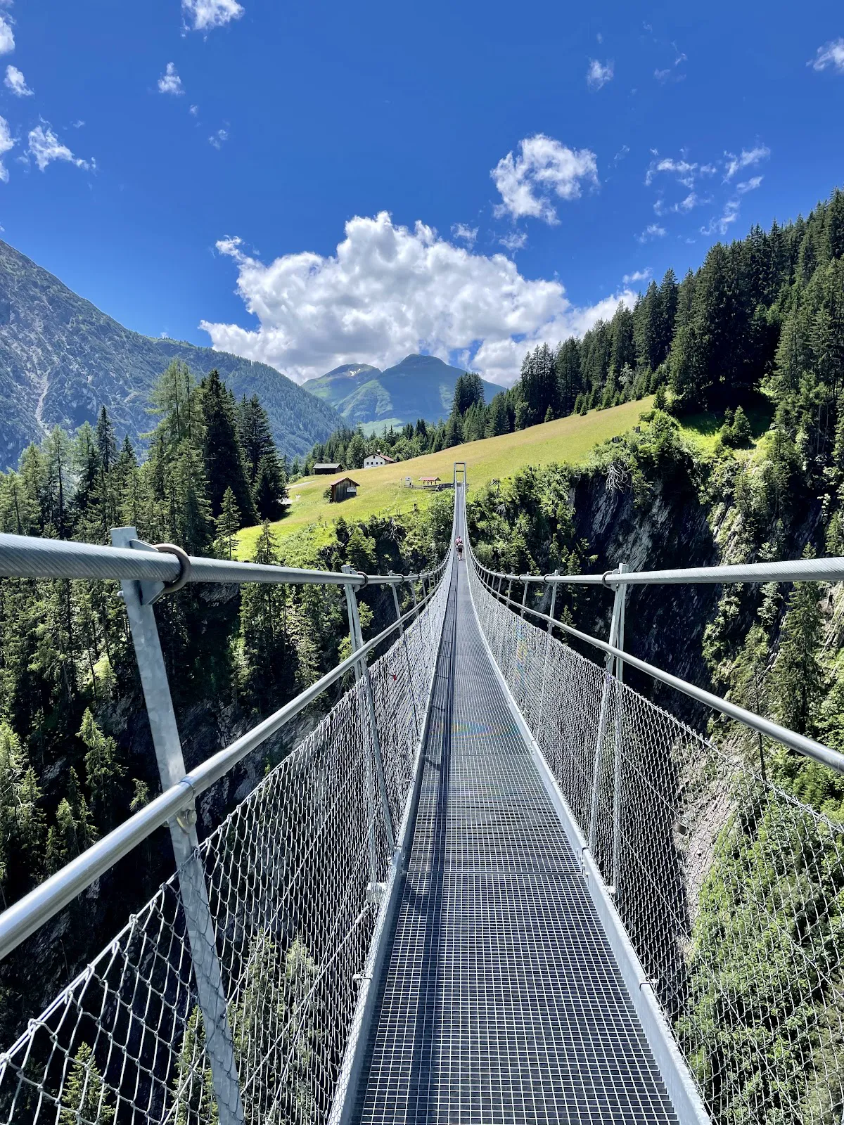
The walkway is only 1.2 meters wide. Two-way traffic forces intimacy. The unwritten rule: the person who looks more terrified has the right of way. Backpacks often brush the railing.
Technical Anatomy: Engineering the Void
The structure is not a rigid thoroughfare; it is a dynamic, catenary suspension system designed to harmonize with the kinetic energy of the environment. This ensures structural integrity but introduces movements that the human vestibular system interprets as danger.
| Specification | Data |
|---|---|
| Total Span | 200.5 meters |
| Vertical Clearance | 110 meters above Höhenbach stream |
| Load Capacity | 630 persons (theoretical) |
| Walkway Width | 1.2 meters (single file passing) |
| Cable Thickness | 50mm steel, anchored in limestone bedrock |
| Deck Surface | Galvanized steel grating (see-through) |
| Lighting | LED illuminated at night |
WHY THE GRATING? The open steel grid serves two functions: (1) allows snow to fall through in winter, keeping the bridge self-clearing, and (2) forces you to look directly into the abyss with every step. There is no visual refuge. This sensory dissonance is the primary driver of the thrill factor.
The Crossing Stages: A Chronology of Fear
Field observations suggest the crossing experience breaks into four distinct psychological stages:
Stage 1: The Entry (0-20 meters)
Deceptive stability. Proximity to the massive concrete pylons makes the deck feel relatively rigid. Confidence is typically high in this sector. Most selfies are taken here.
Stage 2: The Drop (20-80 meters)
The rigidity vanishes. Sway becomes perceptible. The gorge floor drops away exponentially. This is the "Freeze Zone" where acrophobia manifests, causing some to grip the handrails excessively or halt entirely.
Stage 3: The Apex (Midpoint)
Exposure is absolute. You are suspended 110 meters directly above the Simmswasserfall's drainage basin. Wind is strongest here, unblocked by the forest. The psychological load peaks as the brain struggles to reconcile height with the narrow path.
Stage 4: The Ascent (120-200 meters)
Due to the catenary curve (sag) of the cables, the second half involves a slight uphill gradient. The physical exertion of walking uphill often overrides the fear response, providing relief and accomplishment as the far pylon approaches.
Access Vectors: Hiking Routes
There is no elevator, no funicular, and no drive-up viewpoint. This physical barrier is the filter that keeps the bridge from becoming as overrun as road-accessible attractions.
| Route | The "Gföll" Loop (Recommended) | The "Simms" Direct Attack |
|---|---|---|
| Starting Point | Holzgau Village (Church), 1,103m | Holzgau Village via gorge |
| Elevation Gain | ~195 meters | ~195 meters (steeper) |
| Duration | 30-45 minutes ascent | 40-50 minutes ascent |
| Trail Type | Wide gravel agricultural road | Narrow forest path, roots/rocks |
| The Reveal | Bridge hidden until dramatic final turn | Waterfall visible early, bridge later |
| Best For | Suspense builders, cleanest approach | Waterfall-first photographers |
The Optimal Strategy
Ascend via the Gföll route (counter-clockwise) for the dramatic bridge reveal. After crossing, descend via the Schiggen path past the Simmswasserfall and Cafe Uta. This puts the "reward" (food and views) at the END of the exertion phase. Do not just walk back—the loop is vastly superior.
Money Reality: The "€3 Truth"
While the bridge itself is free, the logistics involve costs. Early blogs claiming free parking are outdated. As tourism has increased, the municipality implemented managed parking.
| Item | Cost | Notes |
|---|---|---|
| Bridge Entry | €0.00 (Free) | Public infrastructure |
| Parking (Car) | €3.00/day | Gemeindehaus lot. Carry coins! |
| Parking (Bus) | €10.00/day | |
| Public Bus | FREE | With Lechtal Guest Card (from accommodation) |
| Via Ferrata Rental | €15-20/day | Sport Knitel in Holzgau |
| Cafe Uta | €8-15 | Kaiserschmarrn, Strudel. CASH ONLY! |
CASH REALITY: The parking machines and Cafe Uta often don't accept cards reliably in this alpine location. Bring €20-30 in coins and small bills. The frustration of being unable to pay for Kaiserschmarrn after a 2-hour hike is preventable.

The Vertical Dimension: Simmswasserfall Via Ferrata
For the true "Experience Collector," the suspension bridge is merely the warmup. Hidden within the spray zone of the Simmswasserfall is a sport Klettersteig designed for agility and exposure.
The Route
- Classification: B/C (Moderate) with D (Difficult) variants
- Defining Feature: Three distinct rope bridges crossing the roaring stream. Dynamic, bouncy, and often wet from spray.
- "Steinbock" Variant: Near the top, a harder C/D branch tackles a steep rock face and small overhang. Requires upper-body strength.
- Interaction: The suspension bridge crosses directly OVER the Via Ferrata. You can watch climbers from above, or climb the route and use the bridge as your exit.
Safety Critical
- Mandatory Gear: Helmet, harness, and Via Ferrata Y-lanyard with energy absorber. No exceptions.
- Seasonal Closure: Closed late October through mid-May. The gorge creates massive ice buildup on cables and rock. Attempting to climb when ice is present is potentially lethal.
- Gloves: Leather-palmed climbing gloves strongly recommended—cold water spray and frayed steel cables.
GEAR RENTAL WARNING: During high season (July/August), Sport Knitel's rental stock can be depleted by mid-morning. Arrive at opening time (08:30-09:00) to secure equipment.
Seasonal Intelligence
| Season | Conditions | Notes |
|---|---|---|
| Summer (Jun-Aug) | Maximum accessibility. All facilities open. | Heat traps in gorge. Afternoon thunderstorms common. Evacuate the steel bridge at first sign of thunder! |
| Autumn (Sep-Oct) | The "Golden Season." Larch forests turn brilliant yellow. | Crowds thin. Crisp air, unlimited visibility. Best photography season. |
| Winter (Dec-Mar) | The "Ice Walker" era. Stark monochromatic beauty. | Micro-spikes MANDATORY. Wind chill can drop below -10°C. Cafe Uta may be closed. |
| Spring (Apr-May) | Least predictable. Snowmelt creates muddy trails. | Via Ferrata often closed due to residual ice. Check locally before hiking. |
The "Flag Test"
Before hiking up, observe the flags in Holzgau village square. If they are snapping violently or fully extended, conditions on the bridge—110 meters higher and more exposed—will be significantly more intense. In sustained winds above 30 km/h, expect noticeable sway. At 50 km/h, the movement becomes difficult for the average person to manage comfortably.
Combo Strategy: The "Holzgau Triple Crown"
To maximize Return on Adventure, stack experiences rather than viewing the bridge as a single objective.
Summer Strategy (3-4 Hours)
- 08:30: Park at Holzgau Gemeindehaus. Walk to Sport Knitel for Via Ferrata gear (if needed).
- 09:30: Hike the Schiggen route toward the waterfall.
- 10:15: Gear up at the base of Simmswasserfall.
- 10:30-12:30: Climb the Via Ferrata. Experience the wet rope bridges.
- 12:30: Top out near bridge level. De-gear.
- 12:45: Lunch at Cafe Uta. Refuel with Kaiserschmarrn.
- 14:00: Hike connector to the Suspension Bridge.
- 14:15: Cross from North to South (sun favorable for photos looking back).
- 15:00: Descend the wide Gföll path to village.
- 15:30: Return gear. Debrief at village inn.
Winter Solitude Strategy (2-3 Hours)
- 10:00: Arrive (sun is late to rise over the peaks).
- Gear Check: Ensure Grödel (spikes) are on boots.
- 10:30: Hike the Gföll route up. Enjoy the silence of the snow-covered forest.
- 11:30: Cross the bridge. Observe the frozen waterfall below.
- 12:00: Hike down the Schiggen route carefully.
- 13:00: Warm up with hot soup in Holzgau village.
Dining: Cafe Uta
The social heart of the gorge. Located near the Simmswasserfall, this establishment has served hikers for generations.
- The Vibe: Rustic, traditional "Hütten-Flair." Wood paneling, hearty food. Not a slick modern cafe.
- The Menu: Tyrolean staples—Kaiserschmarrn (shredded pancake), Strudel, dumpling soups. Solid, comforting, portioned for hikers.
- The Wait: On sunny weekends, getting a table on the terrace requires patience. Service is friendly but can be overwhelmed.
- Payment: CASH ONLY. There is no reliable card terminal. Bring coins.